 English
  Français
The Place and the People we worked with
The North Devon case study site comprises the marine and coastal parts of the UNESCO designated North Devon Biosphere Reserve (NDBR). This area of over 1000 km² incorporates the internationally important Braunton Burrows sand dune system Special Area of Conservation (SAC), the North Devon Coasts Area of outstanding Natural Beauty (AONB), and Lundy Marine Conservation Zone (MCZ). Important marine and coastal habitats include rocky foreshore, intertidal mud and sand flats, subtidal mud and sand flats, sand dunes and various types of saltmarsh.
The VALMER North Devon case study team worked with a wide range of key local stakeholders within the marine and coastal governance sector particularly the NDBR’s Management Partnership and Marine Working Group.
The Process
Our work in North Devon had three interconnected processes:
Ecosystem Services Assessment (ESA)
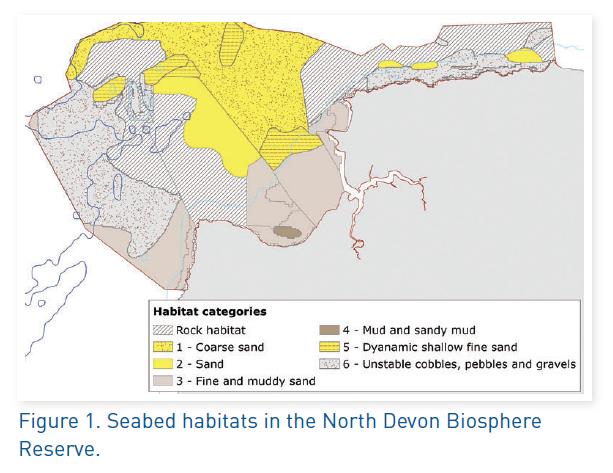
The focus of the study was the area’s extensive seabed muds, sands and gravels, and the role they play in storing carbon, processing waste, and providing nursery grounds for commercial fish and shellfish. Recent and historic surveys, as well as modelled maps, were used to determine the type and extent of different habitats across the case study (Figure 1). The potential level of each ecosystem service was then determined by considering the preferences of juvenile fish and shellfish for sediment type and water depth (nursery provision), sediment mud content (carbon storage) and biological reworking of the sediments (waste processing), and this potential service delivery was then mapped.
Building Scenarios
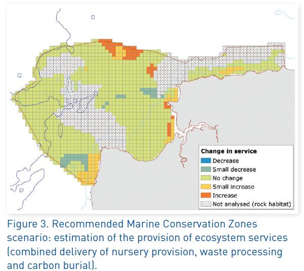
Working closely with stakeholders, plausible, relevant management options were constructed. These explored how delivery of ecosystem services may change with alternative management and use on a 15 year time horizon. Scenario themes were identified, prioritised, and narratives elaborated, with changes to activities/pressures on the seabed then identified. Some scenarios were not progressed including those ranked as low importance or implausible by stakeholders and those with low or unclear seabed pressures. Three scenarios emerged for further investigation:
1. Recommended Marine Conservation Zones designated
2. Aggregate Extraction
3. Aquaculture Development (offshore mussel farm)
Socio-ecological Modelling
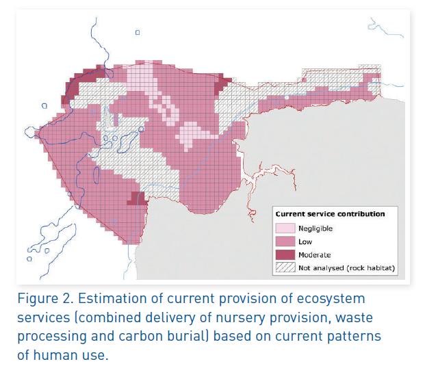
A socio-ecological model was developed to represent the relationship between human activities, subtidal seabed habitats and their ecosystem services. This framework incorporated various types of knowledge including literature reviews for habitat sensitivities and likely pressures arising from activities, relationships between habitats and their ecosystem services from the ESA, and expert opinion. The model was run for each 1km2 of the NDBR using the current configuration of fishing activity to generate service provision maps that represent current provision of ecosystem services from subtidal sediment habitats. Pressure maps elaborated from our three scenarios were then used to condition the model, and the resulting changes in ecosystem service provision were compared to the current pattern.
The Results
The estimation of current ecosystem services provided by subtidal sediment habitats showed the ecosystem services considered here (fish nursery areas, carbon burial and waste processing) are provided in different areas across the NDBR. Considering the three ecosystem service types together, Hartland Point, northwest of Lundy and near Morte platform are the most important areas for provision (Figure 2).
Implications for Governance
This work has many implications for governance but the two most important are:
1. Maps of potential delivery of ecosystem services can inform management. These maps identify important areas for fish nursery provision based on habitat and depth preferences of commercially important species. The Inshore Fisheries and Conservation Authority are interested in using these maps to inform their activities, as is the NDBR management partnership.
2. Trade-offs between different ecosystem service types can be visualised spatially, taking into account secondary effects of management interventions (e.g. displacement of fishing activity). This is particularly relevant for the recommended Marine Conservation Zone scenario, as the consultation for Tranche 2 sites commences (including two that fall within the NDBR), and may also inform the management plans for sites that progress to designation.
For more information on the North Devon case study please contact Steven Guilbert: Steven.Guilbert@devon.gov.uk


Comments are currently closed for this case study!